
Lastest news
- Street by street flood map of l’Horta Sud 2024
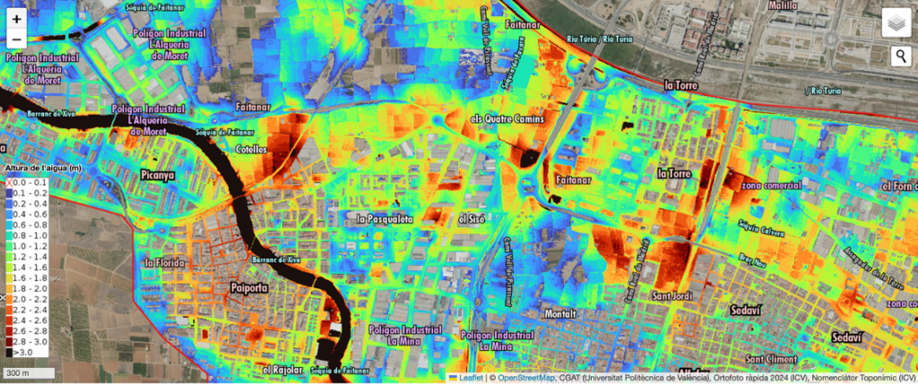 The Geoenvironmental Cartography and Remote Sensing Group (CGAT) from Cartographic Engineering, Geodesy and Photogrammetry Department of the Universitat Politècnica de València (UPV), along with the ETSI Geodesic, Cartographic and Topographic ETSI has prepared this map of the flooding depths in l’Horta Sud after the episode of October 29, 2024. This… Read more: Street by street flood map of l’Horta Sud 2024
 - Our colleague Mª José Viñals awarded at the UPV Research Awards 2024
 Our colleague María José Blasco, together with the researcher María Concepción López, have been awarded in the category of Media Impact of Research Award, within the Research Awards UPV 2024 for their project HBIMSIG-TOURISM which analyzes the impact of touristification on heritage buildings and historic centers through digital technologies. Share:… Read more: Our colleague Mª José Viñals awarded at the UPV Research Awards 2024
 - UPV, a member of the International Federation of Surveyors
 The @UPV is already an academic member of the International Federation of Surveyors. @FIG_NEWS . At the general assembly held in Working Week FIG in Orlando. Share: Share on Facebook Share on Twitter Share on Linkedin Share on Pinterest
 - PhotoMeDAS, 3D modeling to measure cranial deformation in infants
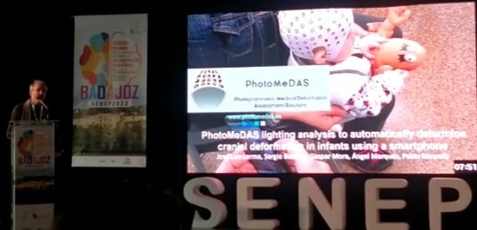 Our colleague José Luis Lerma and his research team GIFLE_UPV presented the PhotoMeDAS application at the XXXVIII Meeting of the Spanish Society of Pediatric Neurosurgery. PhotoMeDAS is a smartphone-based photogrammetric solution for modeling and analyzing with an error of 1.5mm cranial deformation in infants. Share: Share on Facebook Share on… Read more: PhotoMeDAS, 3D modeling to measure cranial deformation in infants
Information of interest

Memory
At the beginning of each year, the department management makes available to you the Annual Report with the scientific production and activities.

Regulation
Regulations of the Department of Cartographic Engineering, Geodesy and Photogrammetry (DICGF) published in November 2012 in the UPV Bulletin (BOUPV).

Virtual machines
PoliLabs virtual machines, with the DIGCF desktop and open source/commercial software used in the teaching laboratories.
Latest videos
Department faculty and professionals comment on the applications of the subjects taught by the DIGCF in the Geomatics Engineering degree program.
Student experiences in the UPV/UPM inter-university doctoral program in Geomatics Engineering.
Blogs
Single-person or group corporate blogs of departmental faculty members
Plans and Property
Issues related to the graphic representation of the territory and the delimitation of property, whether public or private.
Administrator: Carmen Femenia
Natalia Garrido
Related topics on GNSS and property delineation.
Administrator: Natalia Garrido
CartoSiG
Topics related to spatial databases, GIS and spatial data infrastructures.
Administrator: José C. Martínez
CCASAT
Cartographic Coordination in the Territorial Administration System (CCASAT).
Administrator: Carmen Femenia
CGAT
Geoenvironmental Cartography and Remote Sensing Research Group (CGAT)
Administrator: Josep Pardo
GiFLE
Photogrammetry and Laser Scanning Research Group (GiFLE)
Administrator: José Luis Lerma
